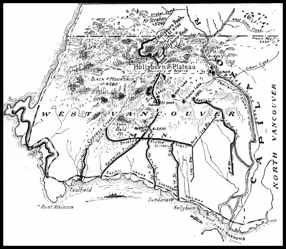
Hollyburn Ridge & Cypress Provincial Park
For people whose connection with the mountain goes back several decades, the name “Hollyburn” evokes many thoughts and emotions, much like the name “Shangri-La” does for people of a certain age. Most of the key geographic features that are connected with the history of Hollyburn lie within Cypress Provincial Park.
1. The MOUNTAIN PEAKS and related high points:
The Lions, Unnecessary Mountain, Mount St. Marks, Mount Strachan, Black Mountain, Hollyburn Mountain; the Hollyburn shoulder, Hollyburn Ridge.
2. The MOUNTAIN LAKES & PONDS
a. THE LIONS glacial ponds
b. HOLLYBURN LAKES & PONDS:
The Hollyburn shoulder - Heather Lakes
The Hollyburn plateau lakes & ponds - Triangle Lake, Sixth Lake, Fifth Lake, Fourth Lake, Third Lake, Second Lake, Elsvik Lake & Unknown Lake
The Hollyburn Ridge lakes - First Lake, West Lake, Blue Gentian Lake & Lost Lake.
c. BLACK MOUNTAIN LAKES:
Cabin Lake, Theagill Lake, Sam Lake, Owen Lake, Cougar Lakes
d. CYPRESS BOWL LAKES:
Yew Lake
3. CREEKS
a. CYPRESS BOWL
Cypress Creek
b. HOLLYBURN RIDGE
Marr Creek, McDonald Creek (West Branch), McDonald Creek (East Branch), Brothers Creek
For the most part, the creeks that flow southward from Hollyburn Ridge to the sea lie within District of West Vancouver’s upper lands.
During the first two decades of the 20th century, the most frequent visitors on Hollyburn Ridge were loggers who built a network of trails, roads, an inclined railway and flumes to access and transport the abundant timber resources that were harvested on the Ridge. A network of ditches dug by the loggers directed water from the plateau lakes and small creeks to the flumes that carried shingle bolts cut at the Nasmyth mill to the West Vancouver waterfront. By the early 1920’s, the mill was abandoned. By this time, hikers were already using the roads and trails to reach the plateau lakes and Hollyburn Peak. In January 1925, the cookhouse for the mill and several small cabins became the first commercial ski operation on the North Shore Mountains. A year later, after two winter seasons of low snowfall, the cookhouse was dismantled, moved higher up the mountain, and renamed the Hollyburn Ski Camp.
Since the fall of 1926, Hollyburn Lodge, then known as the Hollyburn Ski Camp, has sat on the western shore of First Lake on Hollyburn Ridge. For over 90 years, hikers have been climbing trails near Brothers Creek and Lawson Creek to reach the Lodge. On their way up to ‘the Ridge’, they often stopped at Lost Lake, Blue Gentian and West Lake, known to Hollyburn’s early loggers and hikers as East Lake, Middle Lake and West Lake.
After a relatively short climb above First Lake, hikers arrived on the Hollyburn plateau and the small lakes & ponds clustered around Fourth Lake, where they would sometimes pause for a quick swim. Then, after a long, gradual ascent, they reached the bottom of a steep incline known as Romstad’s hill. (During the winter, the route up Romstad’s extended as far as the Hollyburn shoulder, and for the next three decades was a popular downhill ski run for Vancouver’s first generation of skiers.) Hikers would then follow a summer trail that led gradually westward to the Heather Lakes on the Hollyburn shoulder. After another short, steep ascent, the reached Hollyburn Peak.
For many years, a well-maintained trail on the northwest side of Hollyburn Peak led down to the col between Hollyburn and Strachan Mountains. From there, the trail continued on to the summit of Mt Strachan. Hikers who wanted to bypass Hollyburn Peak and head directly to Mt. Strachan would turn left onto another trail before reaching the bottom of Ramstad’s. This trail, on the west-facing slopes of Hollyburn, went through Strachan Valley and past Frank Lake before reaching the col between Hollyburn and Strachan. From there the trail continued on to the south peak of Mt. Strachan. Today, one can still follow this route, but it is not well maintained.
Hikers whose ultimate goal was the ascent of the West Lion, would descend a gully between the north and south peaks of Mt. Strachan to the Strachan meadows. From there they would climb westward until they reached a long north-south ridge that took them over the summits of Mount St. Marks and Unnecessary Mountain and then on to the Lions. Today this ridge route is part of the popular Howe Sound Crest Trail.
During the twenties and thirties, before the construction of the Lions Gate Bridge, the Hollyburn chairlift, the Sea-to-Sky Highway, and Cypress Bowl Road, hikers wanting to climb the Lions began their journey by taking a small ferry to West Vancouver. They would then hike up to Hollyburn Ridge before following one of two routes described above; quite an amazing feat!
Yew Lake and Black Mountain were two other popular destinations for hikers and skiers in the early days. Hikers would often follow a route similar to that of today’s Baden Powell Trail past Whyte Lake and Donut Rock, through the lake country on Black Mountain and then, onto the summit.
Photos taken by hikers and skiers in the ‘30’s and ‘40’s indicate there was another route that led to a point close to Yew Lake and then up the north facing slopes of Black Mountain. During the mid-1920’s, Hollyburn pioneer, Eilif Haxthow, had a small cabin and a trap line on the north side of Yew Lake, (then called Cypress Lake.) On occasion, Daily Province writer, Pollough Pogue camped near the lake. Most likely, Eilif, Pollough, and other early hikers and skiers heading for Black Mountain followed the old Strachan trail for a short distance, and then followed a westerly route to Yew Lake similar to that of the Baden-Powell Trail today.
